
Bamberton (red "X"). View of YOS and Saanich Inlet from SPAET, 2006. Photo: Gord Brown |
||||||||||||||||||||

Totem pole on YOS (Malahat Mountain). |
YOS (Malahat Mountain) is one of the most sacred places of First Nations on southern Vancouver Island. It is the home of legendary Salish beings including Thunderbird which is represented by a totem pole that stands at the 356 m high tourist viewpoint off the highway (left). In the distance are Saanich Inlet and the Salish Sea, home to the Coast Salish peoples. So spectacular is this panoramic landscape that it was chosen as the frontispiece for the Smithsonian Institution book: Listening To Our Ancestors (below). Not seen, but located just beneath the totem pole, is the industrial mining that has hideously blighted YOS. |
|||||||||||||||||||

Frontispiece for the book that accompanies the travelling museum exhibition, 2005 to 2008. |
||||||||||||||||||||

Bamberton and Three Point Properties development. |
The ugly truth is that in 2008, while the acclaimed exhibit "Listening To Our Ancestors" (above) tours the capital cities of North America, YOS is being desecrated by greedy developers against the will and wisdom of the Saanich elders. Their strong objection to the further ruination of YOS, now by real estate development, is recorded in the 1997 report: First Nations Cultural Heritage. The terrible environmental damage already inflicted on YOS is clearly visible on Google Earth: the totem pole inset shows the location of the Malahat highway viewpoint (left). Degradation and erosion due to mining and deforestation can be seen as well as the logging roads that crisscross YOS and the ever expanding highway that bisects its eastern slope. Especially horrific is the scar left by the Bamberton quarry and cement plant on the shore of Saanich Inlet. Settler society's wrecking of YOS continues with the real estate plan that is being carried out under the noses of the Saanich people without their collective participation. This is a shocking instance of Aboriginal Title and Rights abuse, 37 km north of BC's provincial capital. |
|||||||||||||||||||
| Coast Salish indigenous territories are divided by the artificial border between Canada and the USA imposed in 1848 by the colonial invaders. Straits Salish - Samish elder Lena Daniels (1908 - 2007) is at the centre of a heart wrenching story of Aboriginal Title and Rights abuse. She lost her home on Orcas Island due to an illegal land grab in the 1920s. After her marriage, she moved to the Malahat Indian Reserve at Mill Bay on Saanich Inlet. Her son, Randy Daniels, was elected chief of Malahat First Nation in 2008. Earlier, in 2001, Randy Daniels accompanied his mother on a tour of her Samish San Juan Islands homeland (right), where she viewed her family's traditional reef net fishing grounds. The testimony of Lena Daniels, a remarkable elder who spoke fluently in both the Samish and Malahat dialects of her own northern Straits Salish language, was vital to a landmark indigenous rights court case launched by the Samish First Nation against the US Bureau of Indian Affairs. | 
Malahat Chief Daniels with Lena Daniels. |
|||||||||||||||||||

Rainbow over YOS and Saanich Inlet, 2006. The sacredness of YOS was first violated by non natives when a railroad was blasted across the mountain in 1886. In 1912, the Bamberton cement plant began its vandalism at the base of YOS on Saanich Inlet. A government commission visited the Malahat Indian Reserve on 28 May 1913. Malahat Chief Aleck Peter testified that the reserve belonged to the Saanich Nation. He may be the unidentified "Headman" in the photo (right) who appears to be clad in a Salish blanket woven from mountain goat wool. Chief Peter reported that not many houses had been built since the Malahat moved there two years earlier from the Pauquachin Indian Reserve. The history of the Malahat people and their involvement in the South Saanich (Malahat) Treaty of 1852 is unclear. The commission's final report confirmed that 12 of the 13 reserves belonged to the Tsartlip, Tsawout, Pauquachin and Tseycum Indian bands of the Saanich Nation including "No. 11 - Malahut [sic], 586.00 acres" which was noted for having a "valuable cement deposit" of interest to the new industrial plant at Bamberton: McKenna McBride Report. |

The name of the Malahat Indian Reserve in the Straits Salish language (Sencoten) of the Saanich peoples is above. Malahat Reserve is located at the base of YOS on Saanich Inlet (left). Two km south of the Reserve is Bamberton, an old quarry and cement plant now owned by developers. "Headman of the Malahat Indians," 1913. |
|||||||||||||||||||
|
All of Saanich Penninsula is covered by the two treaties signed in 1852 between Saanich Nation and the colonial governor, James Douglas. See R. Wolfenden, "The Indian Land Question," 1875: Douglas Treaties. The North Saanich (Pauquachin, Tsartlip, Tsawout and Tseycum) Treaty and the South Saanich (Malahat) Treaty total 26,900 hectares (left). See the government "Treaty Area" maps: Directory of Federal Real Property. Like the other twelve Douglas Treaties which promised the protection of the way of life of the First Nations peoples, the Saanich treaties have never been honoured. In effect they were legalized land theft, part of a devious tactic by colonists to force the indigenous peoples off their land and onto designated "Indian Reserves." |
|||||||||||||||||||
It is unclear why the South Saanich Treaty was called "Malahat" (above left), or why there are no reserves on this treaty land despite the existence of many traditional sites including a major village at Cordova Bay. On 13 June 1913, the government's McKenna McBride commission visited an unidentified "Saanich Indian Reserve" (right). The contrived imposition by colonial officials of their symbols of domination on this rigged occasion is apparent by the seven British flags that can be seen in the photo. Saanich Nation reserves are located at traditional sites known by their tribal names (Malahat, Pauquachin, Tsartlip, Tsawout and Tseycum). It is essential to understand that Saanich societies are primarily organized according to complex family relationships rather than on a tribal basis and that they - still today - reflect close marriage ties with other Coast Salish communities. |

"Saanich Indian Reserve," 13 June 1913. |
|||||||||||||||||||

pq'als (Mount Douglas), Saanich Territory. Mount Douglas (above) was known by its Sencoten name of "pq'als" which means "Cedar Hill" long before it was seized and renamed for the first governor of the new British colony. According to Saanich oral history, it was on this high landmark that the Saanich leaders agreed to leave the colonists to their devices as long as the Saanich people could "roam freely" and not be bothered on their traditional hunting and fishing grounds. The socalled "Douglas Treaties" have been the subject of much analysis and controversy. Saanich oral history challenges the validity of the white perpetuated myth of the "surrender" by sale of the land. After all, the Saanich chiefs were no fools, so why would they have given up their valuable land for a mere pittance. On the eastern side of pq'als is Cordova Bay, the site of an ancient traditional winter village and clam beach supposedly protected under the Douglas Treaty. A photo taken c. 1900 records the continued indigenous use of Cordova Bay for sustenance (right). But when it was grabbed by settlers, the Saanich people were forced to abandon Cordova Bay. |

"Indian Clam Bake," Cordova Bay, c. 1900. |
|||||||||||||||||||

James Island, Saanich Territory, 18 January 2008. The 330 hectare James Island lies off Saanichton Bay on the eastern shore of Saanich Peninsula and is part of the traditional territory of Tsawout First Nation. An ancient village site is located here as well as a graveyard. The island was first grabbed by Scottish settlers, then in 1908 it became the private hunting reserve for BC's political elite. In 1913, Canadian Industries Ltd. established here a hugely polluting dynamite plant that produced 900 tonnes of TNT per month during WWII. The plant closed in 1962 and the island was sold to an American IT billionaire in 1994. Tsawout Chief Louie Pelkey, 1949. |

Above is the Sencoten word for James Island, yet another landmark renamed for the first colonial governor James Douglas. Like YOS on the western shore of Saanich Inlet, this is "hot land," contested Indian land under the threat of real estate development. Already a private airstrip and golf course degrade the ecology and ancient Saanich heritage of the stolen island (left). Canadian Explosives Factory, 1913, James Island. Concerned over the new subdivision plans for James Island, in October 2007 the conservation group Islands Trust released the report "A Solution For an Ill Treated Island." Shockingly, it fails to make any mention of Aboriginal Title and Rights. The Saanich people who live on the East Saanich Indian Reserve (Tsawout Village) have a clear view of James Island. Ever since the 1870s, when the island was stolen from them, they have witnessed its ecological degradation. In a shameful display of hostility toward First Nations, the current owner of James Island has banned the Saanich people from setting foot on it. A photograph of the hereditary Tsawout Chief Louie Pelkey (1860 - 1953) at Saanichton Bay with James Island in the background was published in "Coast Salish Essays" by Wayne Suttles (left). Chief Pelkey was one of those who took part in the historic longhouse meeting in 1924 during which the Saanich understanding of the 1852 Douglas Treaty as an agreement for peace - not a surrender of land - was reaffirmed. Today his great grandson, Eric Pelkey, continues to press for the Saanich Douglas Treaty rights to be honoured, including the return of James Island and other sites encroached on by settler society. A new hindrance in land title research, says Pelkey, is the sudden disappearance of critical maps from the BC Land Title and Survey Authority. See: S. Hume: Fouled - up Mapping Authority (Vancouver Sun). |
|||||||||||||||||||
Eric Pelkey is spokesperson for the Sencot'en Alliance, a political and cultural organization of indigenous peoples who share a common history, language and culture. It was formed in 2001 to stop BC Hydro from putting a natural gas pipeline through Saanich territories. Indian reserves are primary targets for government - big business right of ways. East Saanich Indian Reserve is bisected by Highway 17 which carries some 30,000 vechicles daily yet no money has ever been paid to the Tsawout, whose legal case against the government is over half a century old. History repeated itself in 2007 when the government came out with a 72 page plan to expand Highway 17 without consultation of the Tsawout. Another contentious issue is the archaeological excavation that occurred at Bazan Bay in preparation for a sewage facility just north of the Tsawout Village (right). The Tsawout have a land claim here that is being ignored. |

Bazan Bay excavation, 2007. |
|||||||||||||||||||

Saanich Nations and Bamberton. |
The territory of the five First Nations on Saanich Inlet and Saanich Peninsula is seen on the Google Earth map (left). A yellow tack marks the mining industry settlement, called Bamberton after its British founder, who also owned a quarry and cement plant on the other side of Saanich Inlet. During its lifetime (it finally shut down in 1980) Bamberton supplied much of the cement used to build up BC. The costs of its horrific contamination to the pristine Saanich Inlet with its valuable indigenous fishing grounds have never been calculated. Like James Island, in recent years the Bamberton site has come into the hands of unscrupulous land speculators who are plotting how to maximize their profits by subdivisions into up market "life style" real estate lots. The devious ruse by which they trammel indigenous rights is the notion of environmental "remediation." |
|||||||||||||||||||
Bamberton prospectus, 2008. (Click to enlarge) |
YOS has been encroached on by logging, mining, railway, road and real estate development. This continuous desecration of their sacred mountain has caused a deep sense of loss and despair among the Saanich people whose traditional way of life is inextricably connected to YOS. Their views on YOS are clearly articulated in the document: First Nations Cultural Heritage (1997). Despite this unequivocal rejection of further development at Bamberton, in 2005 the contested 1,463 acre site was once again quasi - legally sold to land speculators who are once again flogging their real estate development plan as "sustainable." |
|||||||||||||||||||
The latest development scheme at Bamberton was revealed by the press in February 2006. In reaction to the surprise news, Sencot'en Alliance chiefs Tsawout Eric Pelkey and Tsartlip Chris Tom held an interview on the dock at Brentwood Bay, across from YOS and the contested site on Saanich Inlet (right). "We'll do whatever it takes to preserve our sacred property," Chief Tom vowed, "It's got to be stopped" Sacred Yos (28 February 2006, Times Colonist). Sencot'en Alliance accuses the Bamberton developers of excluding the Saanich people from the secretive plans and surreptitious laying of foundations for their lucrative project. Not only have they failed to engage in proper consultation, they have unconscionably denied access to the Bamberton site except on their own cynical terms, such as pre arranged firewood pick ups which are falsely recorded as FN consultation. In addition, the developers have exploited bureaucratic loopholes between provincial districts to avoid the federally required environmental assessment process while collecting phoney awards to greenwash their project. |

Chiefs Eric Pelkey (left) and Chris Tom, 2006. |
|||||||||||||||||||

Sacred stream on YOS, 2007. |
Colonization has not diminished the spiritual significance of YOS to the Saanich peoples. Their deep attachment to YOS as a sacred place remains and they continue to use the mountain for gathering the plants and herbs used in traditional medicine. The streams and bathing places on YOS are of primary importance (left). Saanich elders say that formerly there were six streams on YOS, each with a Sencoten name associated with specific medicines and ceremonial purposes. Today five of these streams have been degraded and contaminated by development. Over 60 medicinal plants grow on YOS and are threatened by development. Knowledge of these plants is held within Saanich families and passed between generations. Elder Roy Daniels: "You have to thank nature and plants before you use them. You thank what you use." Elder Edward Thomas: "The medicines are on both sides of the mountain. Some grow on the sunny side, some in the shade. This shows that we own both sides of mountain" First Nations Cultural Heritage. |
|||||||||||||||||||
|
A report on the indigenous use of Saanich Inlet was released in 1995 by the BC Ministry of Environment (left). The printed report features a "Thunderbird and Salmon" design by Malahat Chief Roddy Albert Modeste Sr. (1946 - 2008). Chief Modeste was one of a handful of artists who revived Coast Salish design traditions in the early 1980s. He took part in the Saanich Inlet study as a member of the advisory committee. The report concluded that to preserve the some 100 recorded archaeological sites and to protect land important to traditional First Nations uses, it was necessary to restrict and control development. | |||||||||||||||||||
|
The Environmental Assessment Act of BC dates from 30 June 1995. The Bamberton Town Development project was the first project to come under the new Act. Two years later, in 1997, a 146 page impact assessment report was released: First Nations Cultural Heritage (left). It concludes that the protection of YOS, "its waters, its land and plant resources, is without a doubt the most important issue from the First Nations perspective arising from community interviews." Because YOS is "inextricably linked to all other aspects of the traditional culture of the First Nations peoples," the report concluded that its protection be regarded as urgent. | |||||||||||||||||||
|
Faced with rejection of its plans, Bamberton Town Development Corp. withdrew its cooperation with the Environmental Assessment Office in 1995. It is scandalous that a decade later yet another real estate scheme is underway, this time with a crafty strategy for circumventing proper First Nations consultation. In protest, the Sencot'en Alliance registered a complaint on 9 January 2008 (left). Among other issues, Tsartlip lands manager Wendy Edwards has serious concerns about reports that FN archaeological material has been secretly dumped into the 120 ft deep quarry and that contaminated wastes are leaching into Saanich Inlet. Meanwhile Bamberton real estate is already being advertised: Former cement plant. |
|||||||||||||||||||
|
The current director of the Environmental Assessment Office, Robin Junger, was appointed on 8 October 2007 by the Honourable Steven Point, Lieutenant Governor of British Columbia. Mr. Junger must know about the development that is ominously proceeding at Bamberton because - like the Saanich people who live in Tsartlip Village - he has a clear view of it from his Brentwood Bay home. The affront of this vulgar spectacle to Aboriginal Title and Rights is shocking and requires an urgent and full investigation. Stó:lo Nation Chief Steven Point was sworn in on 1 October 2007 as the first indigenous Lieutenant Governor of BC. To honour and welcome him, on 15 November 2007 a ceremony was hosted by Saanich Nation at the Tseycum Longhouse during which the Lieutenant Governor was given a glass etching of a Great Blue Heron (right). This once abundant native species is declining in numbers on the coast due to marine pollution and decreasing habitat. In 2005, Tseycum Chief Vern Jacks helped to protect a bird sanctuary and heron lagoon at Tsehum Inlet from a marina expansion plan that was supported by the non native North Saanich Council until public opposition forced a change of policy. |

The Honourable Steven L. Point, 2007. |
|||||||||||||||||||
The Lauwelnew Tribal School is a magnificent manifestation of Saanich culture (right). Built in 1989, it faces southwest, toward YOS (below). The Tribal School is located not far from the sacred Saanich mountain Lau,welnew (Place of Refuge), for which it is named. See: Saanich Indian School Board. Tsartlip artist Charles Elliott created the Thunderbird mural that represents YOS, and the Thunderbird totem pole at the entrance to the school. His father was the remarkable self trained Saanich linguist Dave Elliot (1910 - 1986), who invented an orthography to revive Sencoten, the Saanich dialect of the Northern Straits Salish language. Through the adult education initiative at the Tribal School, Saanich elders have played a vital role in preserving and passing to new generations the Saanich language and cultural traditions. |

Lauwelnew Tribal School, 2005. |
|||||||||||||||||||

YOS - evening panorama with setting sun as seen from across Saanich Inlet at Tsartlip Village, 2007. |
||||||||||||||||||||

Young Saanich woman, c. 1868. One of the earliest pictures of the Coast Salish indigenous inhabitants of Vancouver Island was painted in 1860 (right) by Sarah Crease, wife of the first attorney general. According to her description, the scene portrays Tsartlip Indians outside the colonial governor's garden - close to the present Legislature in Victoria. Women and children are seen engaged in domestic activities amidst dwellings made of cedar planks, likely temporary quarters used by the Tsartlip when they visited to engage in trade with the newcomers. |

Above is the expression in Sencoten (pronounced "sen chath en") for the Saanich Nation, also written as WSÁNEC, which means "the emerging people." A rare early photo of a Saanich person is the portrait of a beautiful young woman (left). It was used as a carte de visite (a fashionable type of small photograph). Taken by Hannah Maynard in her Victoria studio (1862 - 1874), it is identified only by the hand written inscription "Saanich." When the Saanich people signed two treaties with the first colonial governor in 1852, the non native population of Vancouver Island was under 500 while the aboriginal population was upwards of 30,000. The Douglas Treaties were supposed to protect Saanich village sites and fields as well as Saanich hunting, fishing and gathering grounds. But these were increasingly encroached on by settlers such as Henry Crease, a failed and landless English lawyer who arrived in Victoria in 1858. He was appointed first attorney general of the new colony in 1860 and proceeded to enact hundreds of repressive laws that served British interests. Thus commenced the legalized theft of Indian land which continues to this day in BC. Tsartlip Indians, October 1860. |
|||||||||||||||||||

Pauquachin Indian Reserve, c. 1932. |
Traditional Saanich longhouses were large multi family structures built of cedar planks hewn from ancient trees. Originally these massive buildings lined the beaches of sheltered bays, facing the sea. "LLALAM" was a remarkable cedar longhouse, over 100 ft in length, in the Pauquachin Village at Coles Bay, North Saanich. It was painted c. 1932 by the English settler Arthur Pitts (left). Also the magnificent dugout canoes on which the Saanich depended for transport were made from giant cedar trees. According to Saanich oral history, when early colonists were discovered to be cutting down valuable big trees for a sawmill at Cordova Bay, Saanich warriors in canoes threatened to attack. Soon afterwards, the colonial governor initiated treaty negotiations with the Saanich to assure a peaceful relationship. |
|||||||||||||||||||

Saanich Willie Jim and Mrs. E. Tait, 1930. The settler - artist Arthur Pitts painted the distinguished Tsartlip Chief Jimmie Jim c. 1932 (right). Saanich oral history tells of a gathering in the longhouse of Chief Tommy Paul in about 1924 where the treaty promises of the colonial governor were discussed in relation to the fishing restrictions being enforced against the Saanich people. Chief Jimmy Jim was said to have stood up and asked "What happened to the word of James Douglas?" A decade earlier, during the 1913 government commission, Jimmie Jim was noted for owning 28 acres of land. Another "Jim" (Edward) of the Tseycum Indian Band testified that he did not want to give up his land "on account of the old people who used to live there" and the graveyard: "the land is our home, and we want to stay there all the time" McKenna McBride Report. |
Few historical photos of the Saanich people exist in the BC Archives. A rare exception is the picture of the Saanich man and woman taken in 1930 sitting outside a building that is likely their home, made of weathered cedar planks (left). In 1981, Tsartlip Dave Elliot identified these people as "Mrs. E. Tait and Willie Jim, related to the Williams family." Born in 1910, Elliott remembered how the old people lived, before their Sencoten language had disappeared. He described the Saanich land and traditional way of life as "a virtual paradise." Tsartlip Chief Jimmie Jim, c. 1932. |
|||||||||||||||||||

Tsawout Longhouse dance, c. 1932. Tsawout Mavis Underwood (right) is executive director of the agency for Salish Child and Family Services: NIL/TU,O. Her grandfather, Bert Underwood, and her great uncle, Sandy Jones, were Shaker healers as well as builders of fishing boats, houses and the Saanich Shaker Church. She describes her background, between the Catholic and Shaker religions of her parents, and how as a child she absorbed the Christian doctrines: My Journey of Faith. NIL/TU,O was founded in 1997 to begin "restoring authority and responsibility for caring for our children" and to "maintain the traditional values of the extended family." According to Mavis Underwood, one of the greatest challenges that faces NIL/TU,O today is the proper response to the new government directive for formal First Nations "consultation" which is widely misinterpreted and mistaken by settler society as meaning merely "engagement," rather than the implementation of Aboriginal Title and Rights. |
A rare view of a traditional Tsawout longhouse ceremony and dance was recorded c. 1932 by the settler artist Arthur Pitts (left). One Tsawout member describes the process by which the Saanich people have become alienated from their cultural identity and practices: "We become acculturated, highly acculturated and then finally assimilated. Less devoted to our own ritual, ceremony and celebration with more or total focus on western - European - colonial celebration." Tswaout Mavis Underwood, 2007. |
|||||||||||||||||||

Tsartlip Chief Tommy Paul, c. 1932. Chief Tommy Paul further testified in 1913: "I understand that Sir James Douglas gave us a big tract of land" but that the Tsartlip Reserve included only 450 acres. He described what happened to the graveyard on Senanus Island, which was supposed to be protected: "The white men set fire to that, and the bones were all burned out." The McKenna McBride Report revealed the travesty of justice carried out by the self serving colonial officials. Jean Baptiste Paul (1896 - 1966) was best known as the "Red Indian Warrior" or Chief Thunderbird (right). Son of Chief Tommy Paul (above), he was an extraordinary world champion wrestler who entered the ring in full native regalia and pounding drums. Chief Thunderbird was famous for a wrestling move called the Saanich Snap. On his arrival in Britain in 1951 on a tour, he cynically joked to reporters: "You must have kept all your nice people here - and sent your mean whites to my country. Because they certainly wound up stealing it from us Indians." On returning to Canada, his comment about Britain was: "They treated me like a human being over there" Chief Thunderbird (SLAM!). |
The respected Tsartlip Chief Tommy Paul was painted by Arthur Pitts c. 1932 (left). Chief Paul submitted one of the longest testimonies to the government commission of 1913. Using an interpreter, he confirmed that of the 60 acres he owned on the Tsartlip Reserve in West Saanich, 20 were in big timber which he was "holding for the use of his family" while the other 40 acres had been cultivated. Thus by the white man's standard of "improvement," Chief Paul was described as a "progressive" Indian. Despite having inherited his land, he was harassed by the government officials for not paying taxes. The Tsartlip chief pointed out how unjust it was that the white settler Frank Verdier had taken 160 acres from protected Tsartlip treaty land and sold it to speculators who subdivided it: McKenna McBride Report.
Chief Thunderbird (Jean Baptiste Paul). |
|||||||||||||||||||
The youngest son of indigenous rights activist Tsartlip Chief Philip Paul (above) is Philip Kevin Paul (right). As well as an amateur lightweight boxer, he is a writer and poet whose work includes an award winning book which he describes as "an elegy for Saanich. For the old names, the old places, the old ideals" Taking the Names Down from the Hill. |
Philip Paul (1933 - 1992) was the uncle of Jean Baptiste Paul (above). He is tributed as "a pioneer in the fight for settlement of land claims, a strong believer in the value of education and a leader among his community and aboriginal people throughout the nation" Biography of Philip Paul (Union of BC Indian Chiefs). In 1986, he narrated four video clips (left) which describe how the struggle to reclaim aboriginal land is about cultural survival: Land is the Culture I - II - III and IV.
|
|||||||||||||||||||

Chiefs Elijah Harper (left) and Tom Sampson, 1986. Testimony by Chief Sampson was crucial to saving YOS from development in 1997. See: First Nations Cultural Heritage. He also participated in the process by which Race Rocks was declared a Marine Protected Area Proposal in 2000 (right). And as a director of the Georgia Strait Alliance, he launched the Coast Salish Sea Council. "We seem to have the attitude that we need to destroy what doesn't pay off monetary value of some kind - that it has no value and should be terminated. Scientists, managers and technicians seem to believe they know more about the environment than our people" Tom Sampson (Georgia Strait Alliance). |
Tsartlip Chief Tom Sampson is seen with Chief Elijah Harper, the Cree aboriginal politician, during a visit he made in 1986 to the Malahat Reserve at Mill Bay on Saanich Inlet (left). Having served as chief for 24 years, Tom Sampson is a witness to the devastating impact of development on Saanich marine resources and on the traditional way of life. He says "It's important that people understand that when we talk about the land we are talking about a relationship that goes back thousands of years. We know this land better than anybody else" First Nations at Race Rocks. Chief Tom Sampson, 14 September 2000. |
|||||||||||||||||||
|
||||||||||||||||||||
Geronimo Canoe Club of Saanich. The Saanich people are renowned for their canoing skills. Watched by some 12,000 spectators, "West Saanich No. 5" won the International Indian War Canoe Race at Coupeville in Washington on 10 August 1936. The famous Saanich - Tsartlip canoe, carved from a single massive red cedar tree, was photographed as it reached the half mile point (right).
Winning Saanich war canoe, c. 1929. |
In the 2008 Tsartlip band council election, Ivan Wayne Morris was voted chief. In 2006, he and fellow Tsartlip Carl Olsen won an important legal case affirming their Douglas Treaty hunting rights: Regina v. Morris. Both also participated in the report on YOS: First Nations Cultural Heritage. In an early, undated photo (left), Ivan Wayne Morris poses with Esther and Emmy Morris. As athletes and members of the Geronimo Canoe Club of Saanich, they were taking part in a canoe competition at Neah Bay in Washington State. Winning Saanich war canoe, 1936. The prize winning war canoe "West Saanich No. 5" is seen in a c. 1929 photo (left). The twelve canoe pullers pose with two of their trophy cups. From right to left: 1) Marshall Henry (the canoe carver and owner), West Saanich and Malahat; 2) Baptiste Paul (the famous wrestler), West Saanich; 3) Joe Seymour, Chemainus Bay; 4) Chris Tom, Cole Bay; 5) Peter Henry, West Saanich; 6) Fred Huston, North Vancouver; 7) Howard Olsen, West Saanich; 8) Fred La Tasse, West Saanich; 9) Jasper Charlie, Beecher Bay; 10) Joe Bartleman, West Saanich; 11) Isaac Bartleman, West Saanich; 12) Johnny Sam, West Saanich. |
|||||||||||||||||||
Tsawout Earl Claxton Sr. and Sencoten map. Goldsteam Indian Reserve No. 13 was set up to preserve a traditional salmon fishery at the head of Saanich Inlet, also the site of an ancient Saanich village and graveyard. Environmental degradation and mismanagement by the federal Department of Fisheries has led to a drastic reduction of salmon and other seafood resources such as clams in the Saanich Inlet. When a commercial fishery was proposed in 2003, it was successfully opposed by the Saanich Tribal Fisheries with assistance from the West Coast Warrior Society. Saanich fisheries and fishing rights as protected in the Douglas Treaties were confirmed in a 1989 Supreme Court decision: Claxton v. Saanichton Bay Marina. |
Tsawout elder Earl Claxton Sr. is an expert on the Sencoten language and on the traditional Saanich fishing resources (left). The mapping of Saanich territory is a crutial part of preserving the language as Sencoten place names for every geographical feature testify to the longtime Saanich relationship to the land and waters. When in 1848 the American - Canadian border was imposed across the Salish Sea, the Saanich people lost their invaluable reef fisheries. On the need to learn from the indigenous conservation ethic, see N. Turner: Coming to Understanding. Spawning salmon, Goldstream River, 2007. |
|||||||||||||||||||
Tsawout Nick Claxton, pit cook, 2007. |
Nick Claxton, like his uncle Earl Claxton Sr., is committed to revitalizing traditional Saanich fishing knowledge in his community. Left are photos of Nick instructing Pacheedaht youth on how to build a traditional salmon pit cook on the beach in 2007. His MA thesis "The Douglas Treaty and WSÁNEC Traditional Fisheries: A Model for Saanich Peoples Governance" was completed in 2003 at the University of Victoria, where he is now finishing his doctorate. Nick's call for the restoration of Saanich sovereignty and self governance over their land and resources is convincingly supported by his research: WSÁNEC Traditional Fisheries. The Tsawout Village is located at the mouth of TETAYUT (Sandhill Creek) which has been severely damaged by contamination from non native urban sprawl: Raw Sewage Kills Trout (22 August 2007). |
|||||||||||||||||||
|
Urban sprawl and real estate development has not only degraded the land and waters of the Saanich Nation, it has desecrated Saanich graves and obliterated archaeological sites. This shameful action began with the arrival of settlers in the mid 19th century and has only intensified as the land was increasingly subdivided by property speculators and developers. Most Saanich mortuary artifacts were long ago looted and carried off by collectors, ending up in private collections and museums across the world (right). Left without the objects of their material culture, the Saanich people relied on their elders to pass on their knowledge. Tsawout elder Elsie Claxton (1911 - 1990) was born on the East Saanich Reserve of Saanichton Bay. Given a traditional education by her parents: she was fluent in the Cowichan language and understood several dialects of North Straits Salish including Lummi, Songish and Sooke. Elsie taught Sencoten to her five children, including Earl Claxton. Sencoten geographical place names speak to historic land occupancy and ownership. See: Saanich Classified Word List and Morphology and Phonology of Saanich.
|

Tsartlip mortuary box. The condemnation of grave desecration written in 1955 by Mrs. Underwood (left) continues to be an issue of abuse today. On the shocking human rights violations that occurred on Valdes Island in 2001, see the essay by Laayksen Robina Thomas: Laayksen Mustimuhw and Snuw'uy'ul (Celànen). In the 1998 report on YOS, Tsartlip elder Samuel Sam spoke of the devastation caused by settlers: "they've destroyed the spiritual ways of the Indian people. We're losing reverence for nature ... young people don't have the same spirit, the same strength as the old people, because nature is destroyed" First Nations Cultural Heritage. |
|||||||||||||||||||
|
Saanich graves have been repeatedly robbed and vandalized by many, including American Museum of Natural History employee Harlan I. Smith, who sold artifacts and human remains to museums world wide. Tseycum Chief Vern Jacks says "These people dug up our gravesites and they took our people away. They didn't even ask us." His wife, Cora Jacks, adds "We have a close tie with the spirits of our ancestors and a part of their spirits are with the bones" Lost Ancestors (The Martlet). The ancient Salish burial cairns at Race Rocks are an instance where non invasive archaeological research is being carried out based on ethical guidelines (left). See: First Nations Burial Cairns. The greatest destruction today results from the building boom in real estate and infrastructure. A notorious example is the luxury Poets Cove Resort on South Pender Island which wrecked an ancient village and cemetery site in 2003. In 2006, when a new sewage line uncovered c. 4,000 year old human remains on West Saanich Road (left), Tsartlip Simon Smith, who has the hereditary Coast Salish position of grave digger, was called to the site: Digger of Graves (Globe and Mail). |
|||||||||||||||||||
|
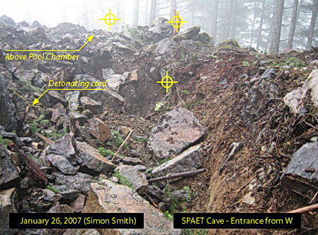
To stop Bear Mountain Resort developers from destroying the sacred SPAET cave for a golf course, Saanich elders held a community meeting on 5 December 2006 at the Tsartlip Longhouse. Elders spoke about the traditional spiritual use of SPAET cave and SPAET subterranean waters (right). According to their customs, such subjects are "taboo" and therefore not normally openly discussed. Non native archaeologist Eric McLay explains that for the Coast Salish, sacred caves and pools are places of spiritual retreat, supernatural wonder and locations to find traditional medicinal plants. Such places are not publicly spoken about: these are private family knowledge and it is very difficult to release the locations and diminish the spiritual potency. In 2007 Tsartlip Simon Smith documented the destruction of the SPAET cave by Bear Mountain Resort (right). A letter by the Sencot'en Alliance to Justine Batten, director of the BC Archaeology Branch, condemns the lack of proper consultation in relation to SPAET, a traditional Saanich hunting and gathering area that includes the Goldstream Indian Reserve and the rare and endangered karst cave near Langford Lake: "We are perturbed about the exclusion of the Saanich Nation regarding the development plans and the findings on SPAET Mountain and in the Bear Mountain Development area" Sencot'en Alliance (28 January 2008). |
|
|||||||||||||||||||
Missing artifact, Helen Point, Mayne Island. In August 2007, a massive Saanich stone bowl believed to be between 4,000 and 6,000 years old was stolen from Helen Point beach on the Mayne Island Indian Reserve which belongs to Tsartlip First Nation (above). The ancient Saanich bowl was exposed by wash from the BC Ferries and other heavy boat traffic using Active Pass to travel between Vancouver Island and the mainland (right). The loss of the bowl is a painful blow to the Tsartlip, who are having to fight in court to prove their occupation and use of the Gulf Islands in order to fend off territorial takeover attempts by the BC Treaty Commission. Its hasty signing of the Tsawwassen Treaty on 10 October 2007 is a devious ploy, says Tsartlip Chief Chris Tom, of "taking from Peter to pay Paul." |

BC Ferry traffic, Active Pass. |
|||||||||||||||||||
The Sencot'en Alliance issued a call for First Nations support: "The new Tsawwassen Treaty will give away a major part of our core territory in the Gulf Islands where we hold the Aboriginal Title and Rights. Our Constitutionally protected rights under the Douglas Treaty will be impacted by this new kind of Treaty" News Release (Union of BC Indian Chiefs). Much of the problem is caused by the 1883 Dunsmuir land grab that dispossessed First Nations of one quarter of Vancouver Island (right). By not allowing this land on the treaty negotiating table, the government forces First Nations to fight for land other than their original core territories. One of the few political leaders to take a principled stand and reject the unethical and self serving government - big business collusion behind the Tsawwassen Treaty is MLA Michael Sather: "The treaty process, as shown by the actions of the provincial and federal governments, was not respectful of first nations. First nations had been treaty - making long before the white man came to North America. They have been working out how to share resources between their territories down through the ages. They have a respectful process to do that, which includes consultation between hereditary chiefs, elders and now band councils" Hansard Transcript (BC Legislature, 22 October 2007). |

Dunsmuir Land Grab, 1883. |
|||||||||||||||||||

Saanich protest, Victoria, 15 October 2007. |
"We are Straits Salish People, also known as the 'salt water people' because we lived from the bounty of the ocean and the land. Our summer homes were among the protected bays and inlets of the Gulf Islands and San Juan Islands. Our winter homes were in WS'NEC, meaning 'emerging land' or 'emerging people' since the time of the great flood. Our name, WS'NEC, was anglicised to 'Saanich' when the white people arrived in our territory. Today the WS'NEC live on four small reserves at the location of our winter village sites. The language of the WS'NEC People is SENCOTEN, taught at LAU,WELNEW Tribal School" First Voices. On 15 October 2007, the Sencot'en Alliance organized a protest against the Tsawwassen Treaty (left). The Saanich people are demanding recognition of their 1852 Douglas Treaty protected territorial rights, which include the southern Gulf Islands. Also the Gulf Islands National Park Reserve, established in 2003, has failed to recognize Saanich title and rights to the marine resources and traditional food harvesting sites. |
|||||||||||||||||||
The Saanich Nation has initiated a number of landmark legal cases based on their Douglas Treaty rights to hunt and fish "as formerly" on their traditional lands and waters (right). The most recent case, by appellants Ivan Wayne Morris and Carl Olsen, was launched after government employees tried to trip them up with a decoy deer. The Saanich victory showed for the first time in BC that First Nations treaties can be paramount to provincial law, an important case reported internationally: Native Canadians Win Hunting Rights (BBC). Despite this legal victory, in 2006 the developers of Bear Mountain Resort served Tsartlip Chief Chris Tom with a punitive one million dollar law suit to keep him and other natives from setting foot on their former hunting grounds. |
|
|||||||||||||||||||
|
The Sencoten word for the sacred Saanich mountain known as Lau,welnew (Place of Refuge) is on the right. When colonists first surveyed Vancouver Island in 1855, Lau,welnew was renamed "Mount Newton" after a minor draftsman. Despite the ensuing flood of newcomers, the cultural significance of Lau,welnew has endured in Saanich oral history. See: Legend of Lauwelnew (Saanich Indian School Board). The side of Lau,welnew facing Saanich Inlet was protected as part of the Pauquachin Indian Reserve while the rest was grabbed by settlers. In 1921 John Dean donated his land on Lau,welnew for a provincial park that today covers 455 acres, and in 1985 the owners of Poole Construction Ltd. (Canada's largest construction company) donated a further 100 acres of the northern slope of the mountain to the University of Victoria along with a residential facility for the rehabilitation of well heeled alcoholics. The University of Victoria renovated the large facility and converted it into an upmarket residential conference centre called Dunsmuir Lodge (right). It would be appropriate for University to tribute the Saanich identity of the mountain, instead of naming the centre after the Scottish coal baron who grabbed a quarter of Vancouver Island. The current function of Dunsmuir Lodge in serving elite corporate executives who fly in to the nearby Victoria Airport from foreign locations does not recognize the ancient indigenous significance of Lau,welnew as a sacred Salish place.
"LE,NONET Project," University of Victora. |

Lau,welnew - Dunsmuir Lodge. Tsawout member Mavis Underwood proposes an alternative: "As the mountain is a sacred place for healing, praying, and retreating, it would be highly appropriate that a new manifestation be considered ... it would be ideal as a centre for indigenous learning, research, youth leadership, development and recovery. It could naturally be a centre for big ideas and creative planning." Tsartlip artist Charles Elliot created a traditional Salish spindle whorl design (left) for the "LE,NONET" aboriginal project at the University of Victoria. He explains, "According to the teachings of the old people in each of our territories, we are never far from the creator, we are connected to all living things and it is focus on and respect for the past which brings us strength to enter a new day and time" LE,NONET Project. |
|||||||||||||||||||
|
In recognition of his work "to bring the visual language of the Coast Salish Nation to life, when it was in danger of being lost," Charles Elliott was awarded the Order of British Columbia. He is seen at his investiture at Government House in Victoria (right) on 29 June 2005 with Dr. Taiaiake Alfred, Indigenous Peoples Research Chair at University of Victoria and director of the Indigenous Governance Program. It is unacceptable that in 2008, the Saanich Nation faces the spectacle of their sacred mountain YOS being desecrated by profit crazed developers. We have much to learn from the conclusion of the 1997 report on YOS: "In sum, teachings of the First Nations of the Saanich Inlet speak of the land, the water and the people as equal members of a complex system, an integrated entity connected through cultural traditions. The landscape, therefore, is essential to the continuity of traditional Aboriginal culture and, like traditional cultures, is threatened by the pace of development in the Saanich Inlet" First Nations Cultural Heritage. |

Charles Elliot and Taiaiake, 29 June 2005. |
|||||||||||||||||||
|
||||||||||||||||||||
|
||||||||||||||||||||


Source: www.firstnations.eu Printed:
Copyright: All Rights Reserved. Researched, written, compiled, formatted, hyperlinked and encoded by Dr. Karen Wonders. Images and intellectual property rights reside with the credited owner. Commercial transmission and/or reproduction requires written permission. Use for educational and research purposes requires proper citation.