
'Namgis First Nation: Gilakas'la - Welcome. Arch at 'Yalis carved by Doug Cranmer. Photo: John Harvey |
|||||

Chief Bill Crammer, fish farm protest, 11 February 2003. |
According to their creation story, the 'Namgis are the people of Gwa'ni (Nimpkish River). The once abundant salmon of Gwa'ni gave the 'Namgis great wealth and defined their cultural heritage. Bill Cranmer (left), Chief Councillor and Hereditary Chief of Namgis First Nation, has been a leader in the battle against open pen fish farms ever since Kwakwaka'wakw Territory was first invaded by the aquaculture industry in the early 1980s. |
||||

Broughton fish farm protest, 11 February 2003. The traditional territory of the 'Namgis people is on the northeastern coast of Vancouver Island, bounded by the watershed of the Nimpkish River and the adjacent marine environment (right). In 1886, the Nimpkish Indian Band ('Namgis First Nation) was allotted a few small reserves totalling less than 600 acres (of a territory approximately 600,000 acres in size). The colonial authorities assumed that because the 'Namgis harvested most of their food from marine sources, they did not need large reserves of land. 'Namgis First Nation asserts Aboriginal Title over all of its traditional land and water territories and is a member of Musgamagw Tsawataineuk Tribal Council (MTTC). |
Standing at the bow of a traditional 'Namgis dugout canoe carved from an ancient cedar tree, Chief Cranmer (left) delivers an eviction notice to fish farm owners Stolt Sea Farm Group and Heritage Salmon Company (now Pan Fish of Norway) as part of a First Nations demonstration against aquaculture in the Broughton Archipelago on 11 February 2003.
'Namgis Territory. |
||||

"Cheslakee's Village in Johnstone's Straits." (Click to enlarge) Titled "Cheslakee's Village" after the 'Namgis chief, the engraving depicts houses made of great cedar planks and painted with intriguing geometric motifs. Vancouver's narrative was reprinted in many European languages with new engravings copied from the originals. "Cheslakee's Village" was also the subject of an Italian engraving printed in colour: Villaggio de Chelaski nelle Stretto di Johnston. A plagiarized engraving of the same scene appeared in the three volume "Gemaelde von Nord Amerika" (1839) by the German geographer and travel writer Traugotte Bromme: "Indianisches Dorf auf Quadra - Vancouver - Insel" (right). |
In 1792 Captain George Vancouver of the British Navy became one of the first whites to encounter the 'Namgis when he anchored near Xwalkw, an ancient village and a "Place of Origin" located at the mouth of Gwa'ni ('Namgis First Nation). The scene was recorded by the expedition artist in a sketch made "on the spot" which was later engraved back in London by the renowned English genre artist John Landseer (left). 
"Indianisches Dorf." (Click to enlarge) |
||||

"The Deserted Village of Cheskakess," c. 1860. Gwa'ni continued flowing on the other side of Nimpkish Lake, to its headwaters at Wa'as (Woss Lake), where the 'Ni'nalk'inuxw people lived. Their village was located on an important ancient trading route to the West Coast, called a Grease Trail after a treasured trade item made from the grease of euchalon fish. In 1894 an English surveyor sketched the primaeval forest at Woss (right) before it was clearcut logged along with the entire Nimpkish watershed. Woss was not included in the reserves officially allotted in 1886. 'Namgis chiefs unsuccessfully requested 100 acres around Woss from the government in 1914. Chief Alf Lageuse complained: "When the first whitemen came here they saw where our village sites were; they were all cleared, and he came along and built his house on these cleared pieces and claimed the land. At the present time, under the circumstances, the people cannot make their living on this land because it is not big enough for the use of my people and myself" McKenna - McBride Report . |
When British naval officer Edwin Porcher sketched Xwalkw in c. 1860 (left), he described it as "The Deserted Village of Cheskakees." This was incorrect as the 'Namgis returned annually to the village during the salmon season. British surveyor Richard Mayne saw Xwalkw in 1860 and reported in his travel account that it had little changed from the 1792 engraving (Four Years in BC, 1862). "Glacier Creek on Woss Lake, July 1894. |
||||
Across from Xwalkw on Cormorant Island is 'Yalis (spreading leg beach), an ancient resource site traditionally used by several tribes. In 1860, 'Yalis was renamed "Alert Bay" after a British naval gunship. Colonial entrepreneurs set up a fish saltery at 'Yalis in 1870 and persuaded the 'Namgis to relocate there from Xwalkw to provide labour for the new factory. One of the first of the new 'Namgis houses built at 'Yalis had a dramatic whale and thunderbird design (right). The same design was repeated in 1980 in 'Yalis, painted on the facade of the U'mista Cultural Centre. "Kwakiutl Indians of BC." Diorama. (Click to enlarge) |

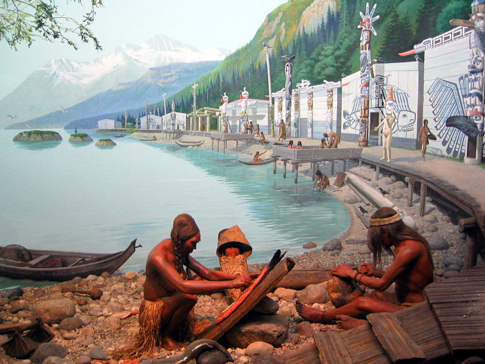
House of Tla-glo-glass, 'Yalis, 1873. With its extraordinary houses and monumental carving traditions, 'Yalis attracted world attention and became the most famous of the Northwest Coast Indian villages. A diorama (left) at created in 1930 at the Milwaukee Public Museum represents a Kwakwaka'wakw scene as it might have appeared prior to European contact. The village is similar to 'Yalis (see the house with the distinctive raven carving on the far right). Some of the first ethnological dioramas in the US focused on the Kwakwaka'wakw: the US National Museum (1896), the American Museum of Natural History (1896) and the Field Museum (1904). |
||||

Unidentified Kwakwaka'wakw family, 'Yalis, c. 1890. A young Kwakwaka'wakw boy (above) in a high ranking family holds a copper, an object of wealth and prestige of the highest denomination owned by chiefs who proved their superiority by fighting each other with property. Coppers were an important part of the potlatch ceremony and its economic exchange of resources and gifts. See: Lori Speck, The Kwakwaka'wakw Potlatch (Umista Cultural Centre). On display at Berlin's Museum of Ethnology in Germany is a magnificent sculpture in red cedar of a Kwakwaka'wakw chief with a copper that was collected by Johan Adrian Jacobsenon in 1881 (right). During the most intense period of museum collecting between 1880 and 1920, the Kwakwaka'wakw population reached its lowest point. Pre existing indigenous social and legal systems were ignored as the colonial government encouraged the alienation of Kwakwaka'wakw territories by settlers and entrepreneurs. In 1878 the English missionary Alfred James Hall moved from Fort Rupert to 'Yalis (Alert Bay). In his journal he described his impression: "the people are very robust and have more activity than other tribes. They live principally on native food and have had little intercourse with Europeans. They spend eight months of the year at the head of Kingscombe (sic) Inlet, but are driven to the coast by the excessive winters of the interior" Church Missionary Society Archive. |

Chief with a copper, Museum of Ethnology, Berlin. |
||||

Women cannery workers, 'Yalis, c. 1900. |
When the federal Kwawkewlth Indian Agency moved from Fort Rupert to 'Yalis in 1896, tribes from the outlying communities were pressured to relocate here. Kwakwaka'wakw women provided an essential labour force for the Alert Bay Canning Company (left). This photo is not the romanticized view of Indian life typical of the period. The four standing women are: (from the left) Catherine Otiohkori, unknown, Jane Hunt, Martha Rufus. During the 1920s, government policies were enforced, including the 1885 Indian Act ban on the traditional potlatch ceremony. On Christmas Day 1921, 'Namgis Chief Dan Cranmer held a large potlatch at Village Island for which he and other participants were arrested and jailed. |
||||
|
At the court trial in Vancouver in January 1922, 49 Kwakwaka'wakw individuals were convicted for potlatch activities, some simply of dancing; 22 were arrested and sentenced to two months in prison; four were sentenced to six months. The others were given suspended sentences after agreeing to stop potlatching and relinquish their ceremonial regalia. Chief James Aud Sewid (1933 - 1988) described the events that took place in 1922 in his 1969 autobiography: Guests Never Leave Hungry. In 1951, Sewid was elected first chief councillor of 'Yalis. His daughter, linguist and author Daisy Sewid Smith (My - yah - nelth), wrote the seminal 1979 essay "Prosecution or Persecution" on the repressive anti potlatch law and its enforcement. In a 1955 National Film Board production, No Longer Vanishing, Chief Sewid asserted his views on Aboriginal Title: "I think the biggest problem to be solved and the most important is the land question. We are non treaty Indians on the coast and I think we should be compensated for our land." |

Chief James Sewid and Daisy Sewid Smith, 1987. |
||||

Sculpture (left) of Doug Cranmer (right). |
The Cranmer Family includes the distinguished carver Doug Cranmer (b. 1927), son of Chief Dan Cranmer. A photo of Cranmer (left) was taken while he posed for a life sized sculpture at the BC Provincial Museum in Victoria. A sourcebook was produced in 1994 during Cranmer's year as resident carver at University of British Columbia's Museum of Anthropology: Doug Cranmer. Gloria Webster Cranmer (b. 1931), daughter of Dan Cranmer, was a major contributer to the revival of Kwakwaka'wakw culture. See her speaking in three documentary videos about the legacy left by Edward Curtis on the indigenous people that he portrayed: Stealing the Soul; Dressing Up; Did He Show Us. |
||||
|
Dan Cranmer's father was Chief Wakus, owner of the first big house to be built in 'Yalis (right) in 1894 and one of the last to stand. Fronting the house was a totem pole, two stories high, carved from a single cedar tree. At the top was Thunderbird (Lord of the Upper World), and below were Killer Whale, Wolf, Wise One, Cannibal Bird and Bear. At the base was Raven. The protruding beak of Raven opened, serving as a ceremonial portal to the house. Later the carved Raven figure was completed in a painting across the facade of the house which represented the history of the Wakas Family. Ellen Neel (1916 - 1966) was born in this house, one of the first female Northwest Coast carvers. The famed Wakus House appeared in the 1914 photo by Edward Curtis: Nimpkish Village at Alert Bay. It was also portrayed in 1986 in paintings by Gordon Miller: Alert Bay and Potlatch Dancers. In 1936, the Wakas Pole was moved to Vancouver when it was bought for display at Stanley Park. The Museum of Civilization in Ottawa purchased the Wakas Pole in 1987 for a permanent West Coast exhibit: Wakus House. A replica house pole carved by Doug Cranmer stands in Stanley Park today: Wakas Pole. 
'Namgis Chief Bill Cranmer, May 2006. |

"A Great Totem Pole." 'Namgis First Nation has a mandate to regain control over its lands, seas, resources and economy while at the same time identifying and protecting its unique cultural heritage. The 'Namgis are demanding recognition "of what is ours and compensation for what we have lost." The 'Namgis want sustainable livelihoods in a commercial fishery that is under their stewardship and management. Chief Bill Cranmer (left) warns of the urgency that faces his people with the ever increasing corporate and industrial exploitation of 'Namgis natural resources: "As the years go by there are fewer trees, fewer fish, our land is being alienated," 'Namgis Treaty News, 2003). |
||||

St Michaels Residential Indian School, Alert Bay, c. 1930. Gwawaenuk Chief Robert Joseph (right) is the director of the Indian Residential School Survivors Society and a respected aboriginal leader. He attended the notorious St. Michaels Industrial Residential School (above), built in 'Yalis in 1894 and operated by the Anglican church from 1929 until the 1960s. Chief Joseph awarded an honorary doctorate on 27 May 2003. See: Doctorate of Law Speech (Turtle Island). Chief Joseph and Hereditary Chief Charlie Williams reject fish farms and in 2003 the Gwawaenuk joined a First Nations lawsuit against the aquaculture industry and government. |

Chief Robert Joseph, 27 May 2003. |
||||

'Namgis House (former residential school), 2004. The 'Namgis name is derived from a mythical sea creature that takes the form of a halibut and whose name translates into "halibut at the bottom." The memorial sculpture "Supernatural Halibut Pole" (right) is 10 feet high and was carved from an ancient red cedar tree by 'Namgis artist Stephen Bruce. It is located in the burial grounds at 'Yalis. See the panorama: Burial Grounds('Namgis First Nation). Fishing was the mainstay of the 'Yalis community throughout the early 1900s. In addition to salmon and halibut, roe herring, rockfish, crab, urchin, geoduck, prawns and clams were harvested. "Fishing for food, and fishing for a living, have been at the core of ‘Namgis culture and economy. For thousands of years the 'Namgis have harvested over 50 different marine resources that together provide a healthy diet from the sea. As well, marine resources were traded first with other indigenous communities, and later with non First Nation interests" Fisheries ('Namgis First Nation). The imposition of European economic systems on indigenous communities created terrible hardship. In 1914 'Namgis Chief Lageuse appealed to the government's Royal Commission: "I ask for the exclusive right for all the people what I have to keep me in food, and that is where I get all that I have, and I want to have these rivers, and I want to have the exclusive right that I may be able to sell the fish after I have used what I want myself." McKenna McBride Report. |
The residential school in 'Yalis is a symbol of colonial oppression to the Kwakwaka'wakw and other First Nations people who were confined here (left). Speaking Kwak'wala was prohibited and Christian values were imposed under military style conditions. The forced removal of children from their homes and communities and other assimilationist government policies contributed to the decline in health of the Kwakwaka'wakw population which hit an all time low of about 1,500 people in the 1920s. Today the negative repercussions of the residential school system are still being felt in First Nations communities. In 1973, St Michaels Residential School was turned over to the 'Namgis First Nation and renamed "'Namgis House." Today it is used as office space for the Musgamagw Tsawataineuk Tribal Council, the Da'nxda'xw Awaetlala Tribe, and Whe - La - La - U Area Council. As the building is not maintained, it is deteriorating and collapsing along with its despised institutional identity. Halibut Pole by Stephen Bruce. |
||||

I'Tusto (To Rise Again), Kwakwaka'wakw bighouse at 'Yalis. |
|||||
|
In 1966, the Kwakwaka'wakw raised a traditional bighouse (Gukwdzi) in 'Yalis. Bighouses are central to governance. See: 'Na'mima System and History of the Big House (U'mista Cultural Society). An arson attack in 1997 destroyed Gukwdzi and was a devastating loss of cultural heritage. The community's determination to build a new bighouse (I'Tusto) was documented by film maker Barb Cranmer in "I'Tusto - To Rise Again." See a video clip: The Bighouse ('Namgis First Nation). On 28 May 1999 a ceremony was held (right) welcoming First Nations guests coming to the grand opening of the new bighouse, I'Tusto. Chief Cranmer said: "With the rebuilding of our bighouse, we've shown the world that we have a strength and culture that can never be destroyed" David Wichar, They Will Dance Again (Raven's Eye). |

Traditional canoe arriving at I'Tusto, 1999. |
||||

Ceremonial welcome at I'Tusto, 9 July 2004. |
On 9 July 2004, a ceremonial welcome was given to the environmental group Greenpeace at I'Tusto in 'Yalis (left). Afterwards a flotilla of protest boats sailed to the contested site of "Heritage Salmon" fish farm in the Broughton Archipelago in Kwakwaka'wakw Territory. This demonstration took place in a community that is struggling for economic survival as a result of drastic fishery restrictions enacted in 1996 try to stop the decline of wild salmon stocks. See Alert Bay's 2006 community report: Adapting to Uncertain Futures. The 'Namgis are concerned that jobs and other economic incentives offered by the aquaculture industry will not compensate for its longterm negative effects including: "the infestation of wild salmon with sea lice, pollution of clam beaches, destruction of seafloor ecosystems, and past use of 'predator' control devices that harm orcas and other sea life" Fisheries ('Namgis First Nation). |
||||
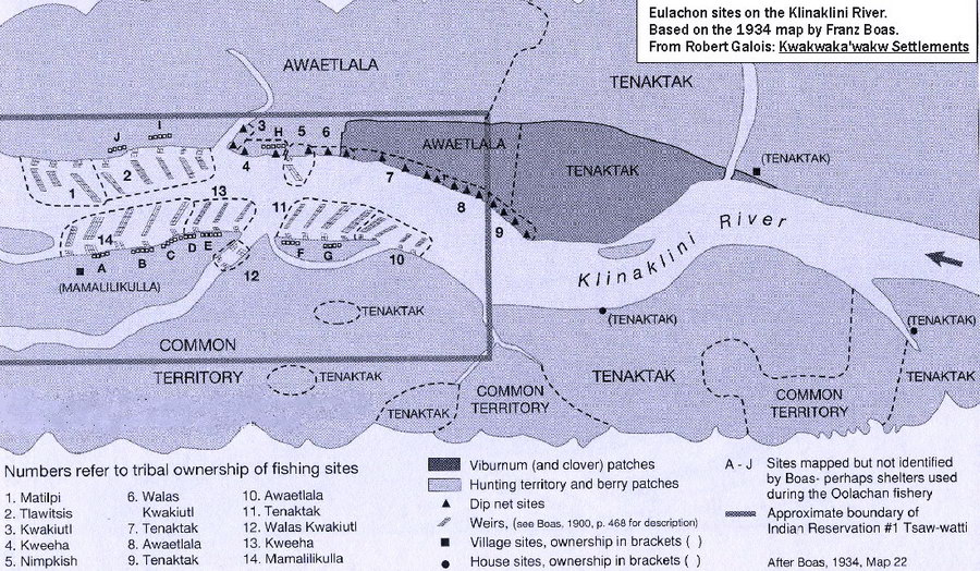
Dzawadi is a "Place of Origin" for the Da'naxda'xw Awaetlala people and the site of the principal eulachon fishery in Kwakwaka'wakw Territory. Since time immemorial, each year the 'Namgis and other tribes, each with their own tribal site, took part in the eulachon fishery at Dzawadi. See: Gloria Webster Cranmer, "Dzaawadi," Anthropologia (2001). Entrance to Dzawadi (Knight Inlet). The eulachon fishery at the head of Knight Inlet (above) and mouth of the Klinaklini River is an ancient aboriginal resource site. Following decades of field research, the well known anthropologist Franz Boas mapped the eulachon sites here. The Boas - based map (right) shows a complex pre existing system of land and water division and resource useage including: dip nets sites; weirs; village and house sites; viburnum, clover and berry patches; and hunting territory. Tribal useages were ignored by colonial authorities who alloted a small single rectangular "Indian Reserve" (right). |

"Dzawadi," 1881. (E. Dossetter) Due to its isolated location, few Europeans had been to Dzawadi (above) prior to an inspection in 1881 by BC's first Commissioner for Indian Affairs. The magnificent bighouses facing the water were built from huge slabs of red cedar harvested from living trees and the towering totem poles and dugout canoes were carved from single trees, some of which were over a thousand years old. Eulachon sites, Klinaklini River. (Click to enlarge) |
||||

Stephen Beans ('Namgis) with T'lina, Dzawaki, 23 April 2002. |
"In the Kwak'wala language t'lina (pronounced 'gleetna') is the name of the precious oil rendered from the eulachon fish. This oil is a symbol of cultural wealth, a valuable trade item and important food staple" 'Namgis film maker Barb Cranmer: T'lina: The Rendering of Wealth. The Kwakwaka'wakw families who travel annually to Dzawadi practice an age old tradition: "It is like travelling back in time as we reaffirm our connection to our traditional territory ... Fish weirs, dipnets, net bags and giant combs were traditionally used to capture the eulachons. A large pit was dug which was filled with eulachons then left to ripen ... " See the online exhibition: Preserving the Tradition of T'lina Making. |
||||
| Along with the eulachons, Knight Inlet is also the annual destination of millions of returning wild salmon. In recent years, the ancient village and salmon fishery of Giyuxw (Glendale Cove) has become world renown for the high number of grizzly bears that come to feed on the spawning salmon (right). Ecotourism companies that offer tours to watch the grizzlies in Knight Inlet pay an honorary fee to the Da'naxda'xw - Awaetlala First Nation.
The Da'naxda'xw - Awaetlala have never ceded Aboriginal Title to their homeland: "Within our Traditional Territory there are culturally significant areas, traditional use areas, registered and unregistered archaeological sites, and other heritage resources that are vitally important to our people" See: Photo Gallery and Da'naxda'xw Cultural Tours. |

Knight Inlet grizzly feasting on salmon. |
||||
Gwa'ni in 'Namgis Territory was once one of the most prolific salmon rivers on the Northwest Coast, having been stewarded by the 'Namgis for thousands of years. At the mouth of Gwa'ni was Xwalkw, an ancient 'Namgis village and "Place of Origin" visited by Captain Vancouver in 1792. Today there are no surviving 'Namgis sites on Gwa'ni, the salmon runs have been virtually eliminated and the forests are second growth industrial tree plantations (right). Gwa'ni was well known for its extraordinary natural wealth of huge ancient trees including Douglas fir, western red cedar and western hemlock. Clearcut logging began after WWII and Tree Farm License 37, as it was called, became one of the largest railway logging operations in BC. From 1960, Gwa'ni provided an annual harvest of approximately 1,000,000 cubic meters per year (a rate of timber extraction equal to 19,950 logging trucks annually). The result was the liquidation of the primaeval forests of Gwa'ni. Bridge over Gwa'ni (Nimpkish River). |

Gwa'ni (Nimpkish River). The recession of logging and fishing industries in the 1970s caused economic hardship on the Kwakwaka'wakw. In 1974 'Namgis First Nation declared sovereignty over Gwa'ni as the "rightful owner and custodian of the watershed and its resources" and formed a Land Claims Committee to take action. The 'Namgis blockaded the Nimpkish River bridge (left) on the only north - south road on Vancouver Island and charged motorists with tolls for entering "Indian Land." The Committee announced that all development in Gwa'ni was to be stopped until land claims were settled so that the waters of Gwa'ni could be preserved from further degradation by logging. |
||||
|
Like Dzawadi, the ancient aboriginal presence at Gwa'ni is revealed by the complexity of places and names that existed here (right). Many named places were very close together; in total 110 places have been identified. See the exhibition: Kwakwala Names (Canadian Museum of Civilization).
'Namgis fishers with drag nets, Gwa'ni, c. 1880. |

Gwa'ni place names. In 1878 the federal Fisheries Act was created, limiting the Indian fishery to harvesting for food, ceremonial or social purposes. Despite their subsistence harvest rights, the 'Namgis were prohibited from using their traditional Gwa'ni fisheries, also on the sections of the river that flowed through their reserves (left). A system of licenses for fishing was imposed by the federal government in 1910 whereby only canneries and white fishers were eligible. |
||||

Salmon cannery label, c. 1900. |
An estimated 46,000 - 82,000 "Nimpkish River" sockeye salmon along with large numbers of Chinook salmon from Gwa'ni were processed annually by the Alert Bay Canning Company (left) from the early 1900s until its closure in 1931. In 1914, 'Namgis Chief Legeuse protested over the exclusive fishing rights given to the Alert Bay Canning Company. See: McKenna McBride Report (Union of BC Indian Chiefs). Later the company was taken over by BC Packers Association, the biggest salmon cannery in British Columbia. |
||||

"Indians fishing on the Nimpkish River," c. 1894. |
The 'Namgis traditionally poled their dugout canoes up Gwa'yi to its headwaters at Woss which was part of a "Grease Trail" connected to the production and trade of eulachon grease: "For thousands of years this precious food seasoning has been made at the mouth of Knight Inlet and transported by canoe and a network of six major trails to neighbouring First Nations on the west coast of Vancouver Island." As part of a new ecotourism and cultural development strategy, the 'Namgis are opening the ancient aboriginal trade routes in 'Namgis Territory and conducting archaeological research at many of the ancient village and fishery sites. See: Tahsis Grease Trail ('Namgis First Nation). |
||||
The industrial logging of 'Namgis Territory did not benefit the 'Namgis. The enormous company profits were not shared nor were the 'Namgis compensated for bad logging practices which resulted in debris torrents and massive silt slides caused by clearcutting steep slopes, logging too close to streams and inadequate road maintenance. Tree Farm License 37 is currently held by Western Forest Products which harvests about 950,000 cubic meters of second growth timber each year from Gwa'ni. The history of the deforestation of the Gwa'ni watershed began in 1917 when an American built a lumber and pulp company at Beaver Cove, an estuary just south of Gwa'ni in 'Namgis Territory. In 1925 another lumber company was built at the nearby Englewood, which was bought in 1938 by Canadian Forest Products (Canfor). In the 1930s, the BC Forest Service documented the so called "Natural Reproduction" (right) of the Gwa'ni (Nimpkish) watershed.
'Namgis fishers with drag seine net, Gwa'ni, c. 1930. |

"Natural Reproduction Nimpkish Area," c. 1930. Ancient cedars can grow up to 2,000 years in age and can never be replaced. Once they are logged, the precious biodiversity they represent is gone forever along with the cultural heritage of the indigenous people who had stewarded the trees throughout the ages. 'Namgis elders warned that the logging of the forests to the edge of Gwa'ni would result in the destruction of the salmon but were powerless to prevent it. During this period, repressive government policies even prohibited 'Namgis fishers from operating drag seine nets on Gwa'ni (Nimpkish River). The photo on the left may record an "illegal" act by 'Namgis fishers. |
||||
Crown Zellerbach bought the Beaver Cove Lumber Co. from Canfor in 1946 and cleared the waterfront at the end of the railroad to Beaver Cove to create a flat log sorting area. In the early 1950s Canfor improved the railroad to streamline transport of logs. The logging of the second growth forests of Gwa'ni continues. In 2003 Canfor built a wood chipping and hog fuel producing facility at Beaver Cove that is the largest in North America. A virtual panorama shows the dry land sort & log booming area at Beaver Cove (right). Using these industrial facilities, Gwa'ni was deforested: what remains today is largely an industrial tree plantation. |

Beaver Cove, 14 July, 2004. (Click for QuickTime) |
||||
Yukusam (Kwak'wala for "shaped like a halibut hook") is a small island that remains one of the few places in Kwakwaka'wakw Territory with primaeval forests and "Granmother Cedars" (right). Many culturally modified trees and other cultural heritage resources are found on Yukusam. In the early 1980s, when Yukusam was threatened with industrial logging, 'Namgis First Nation and U'mista Cultural Centre spearheaded a conservation campaign. In 2003, Yukusam (Hanson Island) was set aside as a protection area to be jointly administered by the Mamalilikulla Qwe Qwa Sot Em, 'Namgis and Tlowitsis First Nations. In 2004, a new protection group was formed: Yukusam Heritage Society.
Orcas at Blackfish Sound, near Yukusam. |

"Grandmother Cedar," Yukusam. The Kwakwaka'wakw give the name "Blackfish" to Killer Whales (Orcinus orca). Blackfish Sound (left) is a body of water adjacent to Yukusam which together with Johnstone Strait has the largest resident orca population in the world. See: Northern Resident Community of Orcas (OrcaLab) and Orcinus orca, a Dutch website which presents the fascinating family trees (clans), distinctive calls and movements of the orcas near Yukusam. |
||||
|
Located close to Yukusam is Usaq (Robson Bight), a Kwakwaka'wakw "Place of Origin." Today it is protected as the Robson Bight Ecological Reserve (right), a sanctuary for orcas. Within 'Namgis Territory there are ten parks and ecological reserves, about eight per cent of the total territory size. In May 2006 the 'Namgis signed an agreement to co manage these areas with the government. Threats to the orcas include toxic pollution, plummeting chinock salmon stocks (a major orca food source) and increased commercial traffic in Johnstone Strait, especially by monster sized cruise ships and transport tankers. 'Namgis artist William Wasden Jr, 1999. |
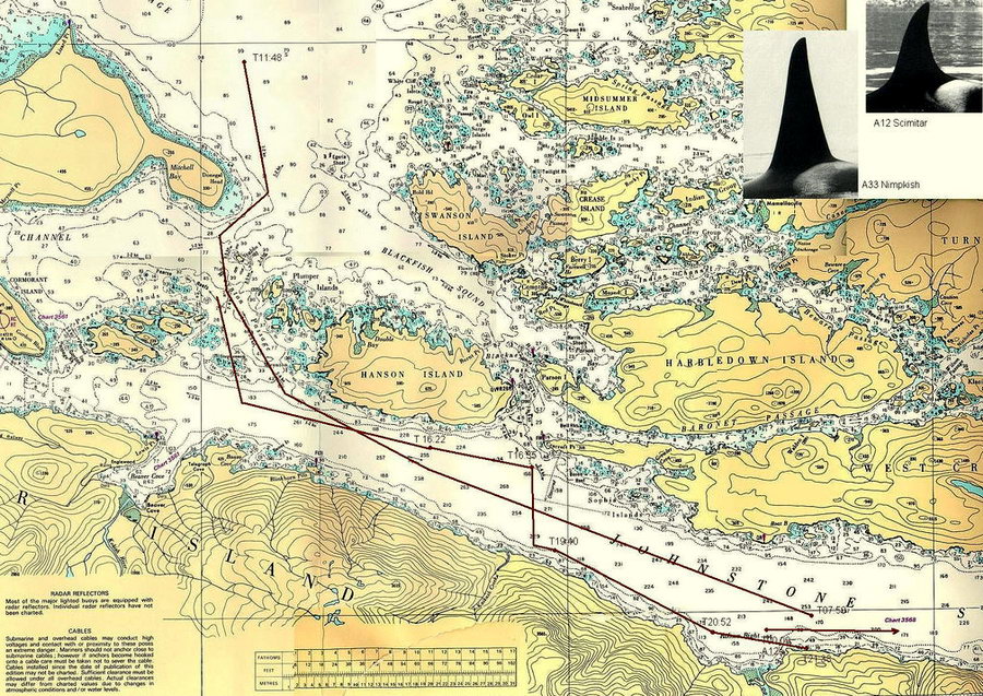
Yukusam navigational map. (Click to enlarge) 'Namgis artist William Wasden Jr. (left) painted a traditional orca design in 1999 on a racing sloop of the environmental group Earth Island Institute. Orcas, five species of wild salmon and many other of the most magnificent marine creatures inhabit 'Namgis Territory including dolphins, porpoises, minke whales, seals and sea lions. This rich biodiversity is an important part of the cultural heritage of the Kwakwaka'wakw. Effective marine stewardship is critical given the fact that the resident southern resident orcas already face extinction along with the chinook salmon runs. |
||||
|
Kwakwaka'wakw territorial waters must be returned to their indigenous stewardship. The 'Namgis justly condemn Canada and British Columbia for discriminating against them and for failing to protect their marine resources: "Fisheries management policies imposed by Canada from the 1960s onward have been designed to eliminate 'Namgis participation in the commercial fishing industry. These policies have favoured large fishing corporations, the commercial sport fishing industry, and multi national owners of environmentally destructive salmon farms [which are] polluting the sea with chemicals, feces, and masses of sea lice. Local salmon stocks that are already under pressure from impacts of industrial logging are now no longer able to also survive harvests" Fisheries ('Namgis First Nation). |

Northern Resident Community Orcas. |
||||


Source: www.firstnations.eu Printed:
Copyright: All Rights Reserved. Researched, written, compiled, formatted, hyperlinked and encoded by Dr. Karen Wonders. Images and intellectual property rights reside with the credited owner. Commercial transmission and/or reproduction requires written permission. Use for educational and research purposes requires proper citation.